StormWatch BiH — Severe Weather Safety App
A smart severe weather early-warning application for Bosnia and Herzegovina, combining forecasts, alerts, radar data and risk intelligence.
Problem
Citizens need clearer and more timely information about severe weather risk at their actual location.
Solution
A safety-first mobile application and backend platform that combine weather data, radar imagery, official alerts and risk analysis.
Result
A local early-warning platform that turns complex meteorological signals into clear safety guidance and targeted notifications.
Key features
- Current weather and multi-day forecast
- Official weather alerts
- Real radar imagery and weather layers
- Storm risk and lightning indicators
- Storm cell tracking and ETA
- Native push notifications
- Administrative monitoring and alert tools
Technical decisions
Native Swift/SwiftUI application
Backend services with PostgreSQL
Multiple weather data providers
Guarded production push delivery
Risk scoring based on multiple signals
Results achieved
- Native iOS push delivery verified
- Real radar and forecast integrations implemented
- Location-targeted alert flow tested
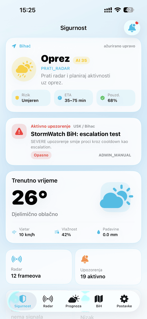
StormWatch BiH — severe weather safety for Bosnia and Herzegovina
Bosnia and Herzegovina is increasingly affected by severe thunderstorms, heavy rainfall, hail, floods and strong wind. These events can develop quickly, while citizens often lack timely information about the actual risk at their location.
StormWatch BiH was created as a local technology project that provides clear and timely information about weather hazards through radar data, official alerts and risk analysis.
More than a weather forecast
Unlike a traditional weather application that focuses mainly on temperature and general forecast data, StormWatch BiH is designed as a safety-first application. The key question is not only what the weather will be, but whether the user is at risk and should take precautions.
Key capabilities
- Current weather and multi-day forecast data.
- Official weather alerts and location-based warnings.
- Real radar imagery and animated weather layers.
- Storm risk, lightning proximity and hail-related indicators.
- Storm cell tracking, estimated arrival time and path visualization.
- Native push notifications and user preference controls.
- Administrative tools for alerts, sources, devices and controlled production delivery.
Risk intelligence
A core part of the project is a custom risk model that combines multiple signals into a simple safety assessment for the user’s location. The model considers radar intensity, nearby thunderstorm activity, official alerts, estimated storm movement and data quality.
The result is presented through clear categories such as Safe, Caution, Increased Risk and Dangerous, so users do not need to interpret complex meteorological maps.
Long-term vision
The goal is to develop a complete early-warning and public-safety platform, with more precise prediction models, advanced radar analysis, intelligent push notifications and future support for additional natural hazards.